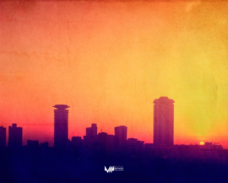
Beauty of our City
Everyday as the sun rises, whenyou wake up in the morning have you ever minded to have a peep out side your window and check the beauty portrayed in the outwards, well this time round NAIROBI29 has it for you. log in daily and have a look of what you know and what you don’t know about your city from beautiful skyscrapers, roads, markets, nightlife and kenya’s pride… wildlife. Know your city and its environs as you see it.
Nairobi-Districts and neighborhoods
Nairobi is divided into a series of constituencies, these are Makadara, Kamukunji, Starehe, Langata, Dagoretti, Westlands, Kasarani, and Embakasi.
The main administrative divisions of Nairobi are Central, Dagoretti, Embakasi, Kasarani, Kibera, Makadara, Pumwani, and Westlands.
Most of the upmarket suburbs are situated to the west and north-central of Nairobi, where most European settlers resided during the colonial times. These include Karen, Langata, Lavington, Gigiri, Muthaiga, Spring Valley, Loresho, Kilimani, Kileleshwa, Hurlingham, Runda, Kitisuru, Nyari, Kyuna, Lower Kabete, Westlands, and Highridge, although Kangemi, Kawangware, and Dagoretti are lower income areas close to these affluent suburbs.
The city’s colonial past is commemorated by many English place-names. Most lower-middle and upper middle income neighborhoods are located in the north-central areas such as Highridge, Parklands, Ngara, Pangani, and areas to the southwest and southeast of the metropolitan area near the Jomo Kenyatta International Airport.
The most notable ones include Avenue Park, Fedha, Pipeline, Donholm, Greenfields, Nyayo, Taasia, Baraka, Nairobi West, Madaraka, Siwaka, South B, South C, Mugoya, Riverbank, Hazina, Buru Buru, Uhuru, Harambee Civil Servants’, Akiba, Kimathi, Pioneer, and Koma Rock to the center-east and Kasarani to northeast area among others.
The low and lower income estates are located mainly in far eastern Nairobi. These include, Umoja, Kariokor, Dandora, Kariobangi, Embakasi, and Huruma. Kitengela suburb, though located further southeast, Ongata Rongai and Kiserian further southwest, and Ngong/Embulbul suburbs to the far west are considered part of the Greater Nairobi Metropolitan area. More than 90% of Nairobi residents work within the Nairobi Metropolitan area, in the formal and informal sectors (jua kali). Many Somali immigrants have also settled in Eastleigh, nicknamed “Little Mogadishu”.
Nairobi-Climate
At 1,795 metres (5,889 ft) above sea level, Nairobi enjoys a moderate climate. Under the Köppen climate classification, Nairobi has a subtropical highland climate.
The altitude makes for some cool evenings, especially in the June/July season, when the temperature can drop to10 °C (50 °F). The sunniest and warmest part of the year is from December to March, when temperatures average the mid-twenties during the day.
The mean maximum temperature for this period is 24 °C (75 °F).There are two rainy seasons, but rainfall can be moderate. The cloudiest part of the year is just after the first rainy season, when, until September, conditions are usually overcast with drizzle.
As Nairobi is situated close to the equator, the differences between the seasons are minimal. The seasons are referred to as the wet season and dry season. The timing of sunrise and sunset varies little throughout the year, due to Nairobi’s close proximity to the equator.
Nairobi-Geographical
The city is located at 1°17′S 36°49′E and occupies 696 square kilometres (270 sq mi). Nairobi is situated between the cities of Kisumu and Mombasa.
Nairobi is adjacent to the eastern edge of the Rift Valley, minor earthquakes and tremors occasionally occur. The Ngong Hills, located to the west of the city, are the most prominent geographical feature of the Nairobi area.
Mount Kenya is situated north of Nairobi, and Mount Kilimanjaro is towards the south-east. Both mountains are visible from Nairobi on a clear day.
The Nairobi River and its tributaries traverse through the Nairobi County.Nairobi’s western suburbs stretch all the way from the Kenyatta National Hospital in the south to the UN headquarters at Gigiri suburb in the north, a distance of about 20 kilometres (12 mi). The city is centered on the City Square, which is located in the Central Business District. The Kenyan Parliament buildings, the Holy Family Cathedral, Nairobi City Hall, Nairobi Law Courts, and the Kenyatta Conference Centre all surround the square.
Nairobi…The History
“A bleak, swampy stretch of soggy landscape, wind-swept, devoid of human habitation of any sort, the resort of thousands of wild animals of every species. The only evidence of the occasional presence of human kind was the old caravan track skirting the bog-like plain.”—THE GENESIS OF KENYA COLONY.
THESE words describe the Nairobi of a little more than a century ago, where lions, rhino, leopards, giraffes, deadly snakes, and myriads of other forms of wildlife made their home. The brave Masai brought their beloved cattle to the fresh waters of a stream located there, a welcome sight for the nomadic communities. In fact, the Masai called the river Uaso Nairobi, meaning “Cold Water,” and the location Enkarre Nairobi, meaning “Place of Cool Waters”—thus providing the name for the area that would completely alter Kenya’s history.
An important event in the development of Nairobi was the construction of the Kenyan railway, once known as the Lunatic Express. By mid-1899, the 327 miles [530 km] of track stretching from the coastal city of Mombasa to Nairobi had been laid. By this time, the construction workers were smarting from their encounter with the famous “man eaters of Tsavo,” two lions that had killed many of the men’s colleagues, and the crew was facing the formidable terrain of the Great Rift Valley. Because the rail line was to penetrate farther into the interior, Mombasa, which had been the main depot, was no longer viewed as a viable location. Instead, in spite of its inhospitable appearance, Nairobi was deemed the best location for a resting-place for workers and an inland depot for construction materials. This helped make way for it later to become Kenya’s capital.
Early in the 20th century, Nairobi was chosen as the administrative center for the newly created East Africa Protectorate, as Kenya was then known. Advance planning would have helped the budding city. Instead, a jumble of rough structures sprang up around the railway station. Made of wood, corrugated iron sheets, and other local materials, the structures made Nairobi appear more like a shantytown than a future international center. The few buildings in Nairobi at the turn of the 20th century were hardly designed with an eye to such a possibility. Also there remained the ever-present threat from the wild animals that roamed the vicinity.
Diseases soon took their toll on the new settlement. An outbreak of plague was the first real test for the new administrators. A quick remedy? The affected areas of the town were burned down to curb the spread! In the next half century, Nairobi would slowly shed its unsightly past and rise to become the commercial and social hub of East Africa.
Nairobi29
Nairobi29 is a brainchild-media house currently in its ‘young years’. It is exclusively created by a group of like-minded student from the East African School of Media Studies based in Nairobi Kenya. The out-of-class project module will see Nairobi29 grow intensively and fast-tracked.
The project seeks to provide visitors to, residents of and any interested parties with more information about the Capital City of Kenya. The project picks us on a zero-online information database lacking in the greater Nairobi. Apart from government and private tour firms in the region, Nairobi score poorly on a dedicated information platform. The Daily newspapers highlight the plight of Kenyans living in the capital rather than offering solid information.The government on the day has tried to avail some of these information yet it is hiccuped by long formalities.
Nairobi City